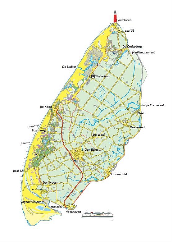
Location-data
Holland, Noord Holland, Island Texel. (4)
Rating :
Objects :
Condition :
Picture time :
Accessible :
Parking :
Date :
GPS :
++++
2+
+++
20 min
++
++
3/2011
BP
Texel, Air field.
WBN, KVA Schagen, Stp.Gr. Texel, Fliegerhorst Texel, Stp. IXb L.

Texel is the first and most south/western island of the "Waddeneilanden" in the Netherlands. The "Waddenstructure" consists of a row of islands from Denmark, along Germany and Holland.

In the northern part of the island lies an air field that has been built already before the war. It was extended by the Germans during wartime. They built several buildings at and around the airfield. Also bunkers in different building type like, Vf-bunkers, Küver-bunker and ST-bunkers.
Next to the air field, that is still in use for small aviation, lies the main road over the island to the north side, called the Postweg. Just in front of the airfield lies the big Fliegerhorst Gefechtsstand-Auswertestelle and more to the south there are several bunkers, now a days used for storage, living or re-used otherwise and hard recognizable as a bunker. A bit further along the Postweg, on private ground lies a Küver 430 still covered with earth.

Types:
1x Vf command post, Fliegerhorst-Gefechtsstand.
1x Küver 430 group bunker for 6 men.
Xx more buildings but no pictures at this moment.
Rating :
Objects :
Condition :
Picture time :
Accessible :
Parking :
Date :
GPS :
Rating :
Objects :
Condition :
Picture time :
Accessible :
Parking :
Date :
GPS :
+++
3
++
20 min
++
+++++
3/2011
BP
+
2
+
20 min
+++++
+++++
3/2011
BP
Texel, Lighthouse.
WBN, KVA Schagen, Stp.Gr. Texel, Lighthouse, Wn. 15 H L., Bpt. 14.

At the most north point of the island there is a big red lighthouse. The lighthouse was heavily damaged by the Germans during the war. After the war the Dutch built a new lighthouse around/over the old structure. Inside you can see the two towers and even remaining building holes.
Two objects are still visible, a Tobruk and a Vf building, that now a days is filed with equipment for the lighthouse like a generator and so.

Types:
1x Tobruk58c.
1x Vf building.
1x Remains.
Texel, "Kleine Slufter".
WBN, KVA Schagen, Stp.Gr. Texel, Kleine Slufter, Wn. 17 H, Bpt. 15b.

At the west side of the island is a so called "slufter". This is a connection with the open sea by an opening in the dunes into the inland. With high an low tide, water is moving in and outside the island slufter.
Driving over the main road, the Postweg, you take the side road called Slufterweg with the number 30 towards the sea. At the end of the road is a restaurant and in its back yard you can find some walls made of German Formsteinen. When you go up the dune by the stairs, you can see some trenches left in the slope.

Types:
1x Wall of Formsteinen.
1x Trenches. (no pictures)
Texel, den Burg.
WBN, KVA Schagen, Stp.Gr. Texel, Stp. Den Burg, Wn. 21 H., Bpt. 20.

Just outside the village of Den Burg, at the west side along the Kogerweg and the crossing with the Georgieweg, lies a R617 bunker and a horse stable.
The R617 was a big and heavy connection point for the German telephone system on the island.

Types:
1x 617 Communication post for telephone exchanges.
1x Fa horse stable, number K19.


*) sources: Paul Dijkstra and www.fortendenhelder.nl
Rating :
Objects :
Condition :
Picture time :
Accessible :
Parking :
Date :
GPS :
++
2
++
15 min
+
++
3/2011
BP
© bunkerpictures - Fliegerhorst Gefechtsstand
© bunkerpictures - Type Tobruk58c
© bunkerpictures - The lighthouse
© bunkerpictures - Oil installations with 2 bunkers
© bunkerpictures - Stable and R617
© bunkerpictures - Type 617