Olst
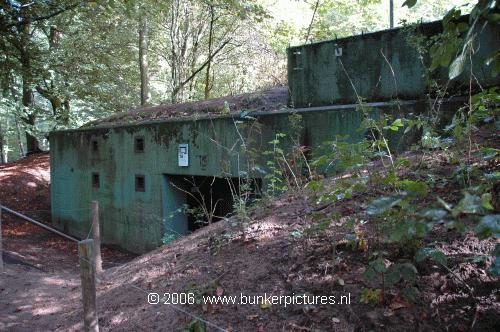
Dutch Cold War IJssellinie.Follow the dike, N337, from Deventer to Zwolle and just before you enter the village of Olst there is a road to the right towards the domain ' Landgoed De Haere'. The bunkers are in the forest. They are in use by a foundation and are normally closed.
The bunkers, a command bunker and a hospital bunker were built for the Cold War. They are part of a larger defence line called 'IJssel linie', a line that was constructed along the river IJssel and should stop/delay the enemy from invading Holland and Europe.
After WW2, Europe created a organisation called the NATO (North Atlantic Treaty Organisation), that combined the armies and defence of all its members. They also expected that all its members, including Holland, participated in the defence of Europe at times of war. Holland was in the 50ties still struggling with the post-war problems and had no money for a proper defence. So the Dutch used there own special (and low cost) weapon; water. Just like in many other conflicts in its history they used the water to defend themselves. The plan in 1953 was to construct a defence line along the 'IJssel' that consisted of dikes, dams, casemates, nets, supporting bunkers and lots of water. There were several locations were, in time of war, the Rine could be closed by means of a floating dam, this would result in a massive inundation of the areas around the IJssel. That was not everything, the water shouldn't get too high because then the enemy (Russia) could use boats to cross the water, it also shouldn't be to low because then the tanks could drive trough it.
This whole operation had the classification 'TOP SECRET' and only a few people in the region knew what was constructed near the river. The civil population around the dams has never been informed about what to do in times that the dams were closed, this means that 400.000 people didn't know what was happening if the water was coming and why they were evacuated Fortunately the dams are never used.
Today the only visible part of the dam at Olst is an abutment for the dam at one of the banks, the other floating dams were placed in
Arnhem and Nijmegen.
When the dam was closed and the inundation started, they needed to control the inundation so they installed several inlet works in the dikes along the IJssel. One of them is at Olst and is recently restored with financial support of the European Union. The inlet work shows us 5 parts that could be closed and opened. The concrete platform in front of the inlet work was to prevent the dike from flushing away when the water came trough the inlet work.
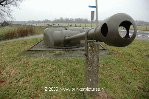
When you follow the dike towards Zwolle you will find a casemate with a tank turret on top next to the road. Along and in the inundation area there were lots of gun casemates and anti aircraft emplacements constructed. There are still a lot of them left, but most of them are buried and some of them are restored by the foundation and are normally closed. The dams were protected against torpedo's with special nets. Those nets were connected to a winch and strongpoints. One of them is located next to the dike.
For more information about this very special project, or when you want to visit the location, go to there website
www.ijssellinie.nl